The drought arrives in the Central Highlands. The decrease of water levels at the many reservoirs, courtesy El Nino weather conditions, had us making a tour to the reservoirs in the Central Highlands for a glimpse of the ancient temples that went under water when the reservoirs came into being. The diminishing water levels meant the monuments were visible in all their ruined glory.
Dried-up reservoir beds are a favourite destination for me as a photographer, and this rare phenomenon has become a tourist magnet and a popular must-see natural wonder for tourists, with large groups of visitors thronging the reservoir bed to pay homage to the ruins of religious monuments that were submerged as the reservoirs were built.
Weather gods
On March 30, 2019, my sons Inura and Thamalka and I journeyed 300 Km from Ratnapura to the Kotmale reservoir in the Nuwara Eliya district, the Maussekelle reservoir in Maskeliya and the Samanalawewe reservoir in the Ratnapura district via Castlereagh reservoir through the Norwood- Bogawantalawa road, all in a day.
We reached our first destination the Kotmale reservoir at 8 am. The journey was exciting because of the anticipation. Driving along the Nawalapitiya-Harangala road, we marvelled at the mountain range giving shelter to the Kotmale valley as we passed Hapugasthalawa. The Kotmale Oya was reduced to less than a trickle in various places, and as we traversed along Harangala, we could see the glistering dome of the Mahaweli Maha Seya.
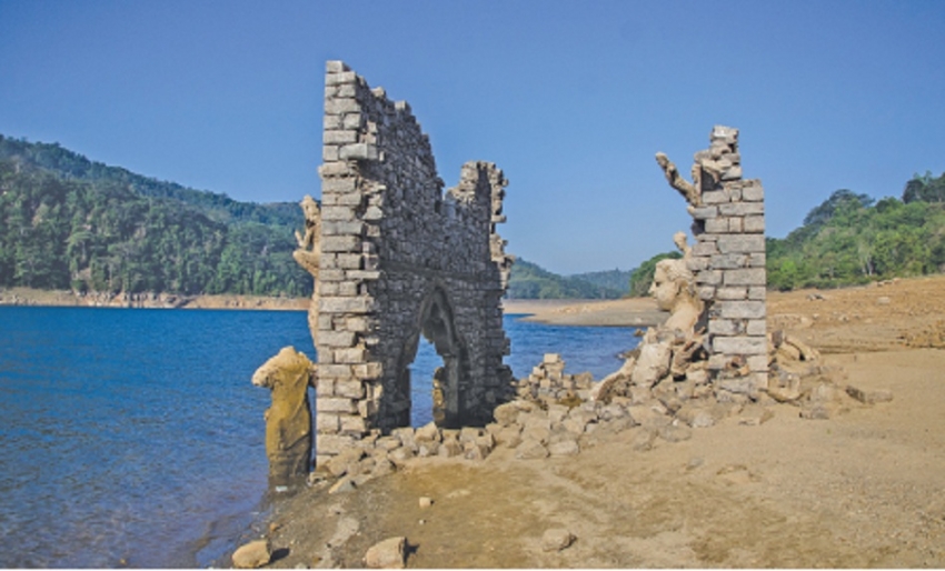
We parked the vehicle in the scorching heat and stepped out to take photographs at the reservoir bed and ruins of a temple.
Many villages and ancient temples are said to have gone underwater when the reservoir was built damming Tispane and Kadadora hills. While many of these temples do not exist at present, some of them stand fully submerged.
Among these, the ruins of the Kadadora Viharaya or Kadadora temple are spectacular, especially, the sculptured statue of the Buddha and the crumbling stone walls of the shrine room. They are a rare sight and can only be viewed according to the whims of the weather gods.
The ruins, which lie nestled under water for more than 30 years, are a nostalgic reminder of the past life of the Kadadora village in the Kotmale valley. They make rare appearances during severe droughts in what is a bittersweet reminder of how the people had suffered.
The Kotmale reservoir was one of the five major projects proposed under the Accelerated Mahaweli Development Program, damming the Kotmale Oya, the main tributary of the Mahaweli Ganga, at Kadadora and Tispane hills. The picturesque Kotmale reservoir was impounded in November 1984.
The massive Mahaweli Maha Seya on top of the hill was constructed to symbolize the religious aspirations of the people whose Viharas were lost forever due to the Kotmale reservoir.
We learned that it is a deeply spiritual and historic place. “After the Buddha statue re-surfaces, it starts to rain ending the drought. It is a miracle. Now we face drinking water shortage, and if the drought prevails it would be worse,” says a local woman who runs a tea kiosk near the reservoir.
After a hot cup of tea we set off to the Maussekelle reservoir via the Nawalapitiya–Ginigathhena-Norton highway, crossing Sri Lanka’s longest river, the Mahaweli. Amazingly, we were running on time, and arrived at the Maussekelle reservoir at 11am.
Past glory
Along the reservoir bed are four temples – the Samadhi Buddha statue, and the ruins of the retaining wall of a Buddhist temple, the Muthu Mariamma Hindu temple, a Muslim mosque and Ganapathi Kovil. The first three are at ground level scattered within a short distance, while the Ganapathi Kovil is a little distance away in a lower section of the reservoir, accessed by a steep slope in the old Maskeliya Town that surfaced due to the severe drought. The ruined Buddha statue and a root of the ancient Bo-tree wrapped in saffron robes lie in the reservoir bed. We spent an hour at the reservoir bed alternating between photographing monuments, strewn here and there in the old Maskeliya town.
In 1968, the Government had planned to build a reservoir to generate hydro-power electricity damming the Maskeliya Oya, a main tributary of the Kelani Ganga originating in the hills of Sammimale, the peak wilderness sanctuary of Sri Pada which nourished the reservoir of Maussekelle. The reservoir was built inundating the old Town of Maskeliya, which is now relocated uphill.
In the past few years, I have been fortunate to repeatedly visit the submerged ancient monuments along the reservoir beds of Kotmale and Maussekelle, but this was my first visit to the Samanalawewa reservoir in the Sabaragamuwa Province. We left Maussekelle at 1 pm taking a narrow, winding uphill route down the picturesque 47 km Norwood – Bogawantalawa road to reach the Samanalawewa reservoir. It is best visited in the evening, as the reservoir-bed is heated up during the day.
The Samanalawewa reservoir, located close to the Belihuloya near Pabahinna, is spread across an area of 897 hect. in a fertile valley of the Walawe Ganga. It is dammed near Pabahinna. The closest and easiest place to visit the dried-up reservoir bed is an old village called Kinchigune, in the Sabaragamuwa Province.
Kinchigune does not exist today as it was submerged in the Samanalawewa reservoir itself, leaving only a handful of original houses at the edge of the reservoir.
It is said that the water level of the reservoir has receded to such a low level for the first time after it was impounded in 1992. The dagoba of the Kinchigune temple and its Warakawela paddy fields too emerged, as the water levels of the reservoir receded.
Walking through the reservoir-bed is a challenge, but we managed to reach the submerged dagoba, about a kilometer away from the edge of the reservoir on stony, muddy ground. It was all worth it.
The small ruined dagoba on a rocky boulder stands majestically in the backdrop of the parched land. Observing the ruined dagoba, we spotted three holes dug in the middle of the structure, perhaps, in search of treasures by organized gangs.
Samanalawewa, in contrast to the other two, does not receive many visitors. It is accessed via a crumbling stone slope of around 10 metres. It is also one of the places where villagers have sacrificed their ancestral properties for the sake of the country’s development.
Today, the water level of many of the man-made hydro-power reservoirs are receding due to the prevailing drought and the ruins of their glorious past have emerged to reveal nostalgic memories amidst the silence that greets you.