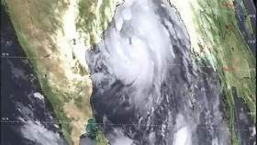
The deep depression over southeast Bay of Bengal to the southeast of Sri Lanka is now located near latitude 4.5N, Longitude 88.0E at 05.30 a.m. of 27th April 2019, about 730 km Southeast of Potuvil. It is likely to intensify into a cyclonic storm during next 12 hours and then into a severe cyclonic storm during next 24 hours. The system is very likely to move northwestwards along and off east coast of Sri Lanka and reach north Tamilnadu coast (India) on 30th April 2019 evening. Cloudy skies can be expected over most parts of the island. Showers will occur at several places in Western, Southern, Sabaragamuwa, North-Western and Central provinces. Showers or thundershowers will occur at a few places elsewhere after 2.00 p.m. General public, Naval and fishing communities are requested to be attentive about future advisories issued by the Department of Meteorology in this reg
WEATHER FORECAST FOR SEA AREAS AROUND THE ISLAND
The deep depression over southeast Bay of Bengal to the southeast of Sri Lanka is now located near latitude 4.5N, Longitude 88.0E at 05.30 a.m. of 27th April 2019, about 730 km Southeast of Potuvil. It is likely to intensify into a cyclonic storm during next 12 hours and then into a severe cyclonic storm during next 24 hours. The system is very likely to move northwestwards along and off east coast of Sri Lanka and reach north Tamilnadu coast (India) on 30th April 2019 evening. Showers or thundershowers will occur at several places in the sea areas off the coast extending from Puttalam to Trincomalee via Colombo and Hambantota. Winds will be South-westerly to Westerly in the sea area extending from Kankasanturai to Hambantota via Mannar and Colombo and winds will be South-westerly to South-easterly in direction in the other sea areas around the island. Wind speed will be (30-40) kmph in the sea areas off the coast extending from Tangalle to Batticaloa via Pottuvil and in the sea areas off the coast extending from Puttalam to Trincomalee via Mannar and Kankasanturai. Wind speed will be (20-30) kmph in the other sea areas around the island.
WEATHER FORECAST FOR NEXT 36 HOURS
The depression over southeast Bay of Bengal to the southeast of Sri Lanka is now located near latitude 2.8N, Longitude 89.7E at 02.00 p.m. of 26th April 2019, about 950 km Southeast of Potuvil. It is likely to intensify into a deep depression and then into a cyclonic storm during next 24 hours. The system is very likely to move northwestwards along and off east coast of Sri Lanka. Cloudy skies can be expected over most parts of the island. Showers or thundershowers will occur at several places in Western, Southern, Sabaragamuwa and Central provinces. Showers or thundershowers will occur at several places elsewhere after 2.00 p.m. Fairly heavy falls about 75 mm can be expected at some places. There may be temporary localized strong winds during thundershowers. General public is kindly requested to take adequate precautions to minimize damages caused by lightning activity. General public, Naval and fishing communities are requested to be attentive about future advisories issued by the Department of Meteorology in this regards.
Weather Forecast for Main Cities Date : 27-Apr-2019
City Temperature (0C) Relative Humidity (%) Weather
Max Min Max Min
Anuradhapura 35 24 90 55 Showers or thundershowers are likely after 2.00p.m
Batticaloa 33 27 85 65 Showers or thundershowers are likely after 2.00p.m
Colombo 34 24 85 60 Several spells of showers
Galle 31 25 85 75 Several spells of showers
Jaffna 34 26 90 60 Mainly fair
Kandy 31 21 95 65 Several spells of showers
Nuwara-Eliya 24 13 90 55 Showers or thundershowers after 2.00p.m
Ratnapura 34 23 95 65 Several spells of showers
Trincomalee 34 26 85 60 A few showers
Mannar 34 26 85 55 Showers or thundershowers after 2.00p.m
Wind speed will be (50-60) kmph over the deep sea areas to the Southeast of Sri Lanka and can be rough at times as the wind speed can increase up to 70 kmph at times. (The wind speed can increase up to 90 kmph at times in these sea areas after the system develops into a cyclonic storm).
The fishermen are advised not to venture into deep Bay of Bengal sea areas to the southeast of Sri Lanka until further noticed.
Naval and fishing communities are requested to be attentive about future advisories issued by the Department of Meteorology in this regard.